Maps of the Earth identify the location of landmarks with two numbers: latitude and longitude. Latitude is measured in degrees north or south of the equator, and longitude is measured in degrees east or west of the Prime Meridian.
A similar system is used for objects in the sky. The celestial equator divides the sky into two hemispheres, north and south. The celestial equivalent of longitude is called right ascension (TheSky uses the abbreviation RA) and the equivalent of latitude is called declination (Dec). Right ascension is measured in hours, minutes, and seconds, from 0 to 24. This may seem odd at first, but there is a very good reason for this peculiar convention: the Earth is rotating. It turns around once on its axis in 24 hours, but from our terrestrial perspective, it looks like the sky is rotating around the Earth every 24 hours. Right ascension is measured eastward from the constellation Aries, the Ram. Specifically, 0 hours RA, the First Point of Aries, is the position in the sky where the Sun crosses the celestial equator on the first day of spring.
Declination is measured in degrees north or south of the celestial equator. The celestial equator is 0 degrees declination. The north celestial pole is located at 90 degrees declination (Polaris, the North Star, has a declination very close to 90 degrees). The south celestial pole is at minus 90 degrees declination. You can also translate right ascension into degrees: a complete circle has 360 degrees; dividing 360 by 24 gives 15, so every hour of right ascension is equal to 15 degrees.
Imagine a line running across the sky from due north to due south, splitting the sky in two. This line is called the meridian. Better yet, turn on the Meridian checkbox under the Reference Lines & Photos group on the Chart Elements window (page 261) to view it on the Sky Chart. When a celestial object crosses the meridian, it is also at its highest altitude in the sky. This is called the transit time. The best time to observe a celestial object with a telescope is when it’s crossing the meridian.
This brings us to another way of identifying the location of an object in the sky: altitude and azimuth. Altitude is simply the number of degrees the object is above the horizon, from 0 (on the horizon) to 90 (directly overhead). Be careful not to confuse altitude with declination – they are not the same thing.
Azimuth indicates the compass direction of an object. Specifically, it is the number of degrees east of north that you need to turn to see the object. Due east, for example, is 90 degrees azimuth.
The problem with using altitude and azimuth for astronomical objects of course is that these numbers are constantly changing as the Earth rotates. TheSky, however, can calculate these numbers instantaneously, making it easier to know what direction to look when you’re outside in the dark, trying to find an object at a specific time.
Ever since we discovered that the Earth isn’t flat, but spherical, cartographers have been looking for ways to represent a curved surface on a flat surface.
A sphere cannot be projected onto a plane without introducing distortion. In the most used projection – called the Mercator projection – objects get larger the farther they are from the equator. This causes Greenland to look nearly as large as the entire United States on a world map. Navigators adopted the Mercator projection because a straight line on a Mercator projection, called a rhumb line, represents a constant compass bearing from true north.
Other projections have their own combinations of strengths and weaknesses. All projections are compromises – the “best” projection is the one whose advantages outweigh its disadvantages for an application.
By default, TheSky uses the stereographic projection for fields of view greater than 60°. A stereographic projection is said to be “conformal.” Although (as with all flat maps) the overall projection is distorted, all lines of declination and right ascension intersect at right angles, as they do on the celestial sphere.
The advantage of stereographic projection is that, over small areas of the display, object shapes are only slightly distorted. Constellations remain easy to identify. Compare this with the polar projection of a planisphere. There is almost no distortion near the poles, but constellations near the horizon are badly stretched out of shape. (A planisphere is one of those rotating star charts that approximate what’s visible in the sky at a given date and time.)
When the Sky Chart is set to a field of view of 60° or less, the projection automatically switches to an orthographic projection, which displays the sky more as it would appear on the surface of a sphere. (This is the only projection used at 60° fields of view and smaller.)
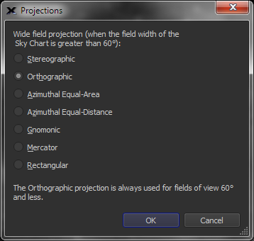
By default, TheSky uses a stereographic projection for 60° fields of view and greater. The Projections command from the Display menu changes the projection. In the Projections window, click the radio button of the projection you want.
Figure 76: The Projections window.
The selected projection is applied to the Sky Chart immediately. It takes effect only when the field of view is greater than 60°—no change occurs if the current field of view is 60° or less.
· Stereographic: The default for fields of view equal to and greater than 60°. It keeps lines of right ascension and declination at right angles and minimizes local distortion. Conformal. 235° maximum field of view.
· Orthographic: Displays the sky more as it would appear on the surface of a sphere. It’s the default (indeed, it’s the only available projection) for angles of view 60° and less. Conformal. 180° maximum field of view.
· Mercator: Shows the celestial sphere like a conventional map. It allows wider fields of view, including a 360° view that shows the entire celestial sphere. Conformal. 360° maximum field of view.
· Gnomonic: This is the “pinhole camera projection.” It displays meteor paths as straight lines, as seen when viewing a meteor shower. Non-conformal. 150° maximum field of view.
· Azimuthal Equal-Distance: The distance between objects having an angular separation on the celestial sphere is the same at any part of the Sky Chart. Non-conformal. 300° maximum field of view.
· Azimuthal Equal-Area: The areas of any sections of the celestial sphere subtending a solid angle are the same at any part of the Sky Chart. Non-conformal. 235° maximum field of view.